High above the clouds: The Grossglockner Hochalpenstrasse carves its way through the Austrian Alps, promising adventure at every turn. Photo by Viktor Hanacek
Short Facts:
Duration of the journey from Chalet Bjoerk: About 1 hour 15 minutes (approx. 80 km)
Recommended Equipment: Camera, sunglasses, windbreaker, warm clothes, and a healthy respect for gravity
Location & History
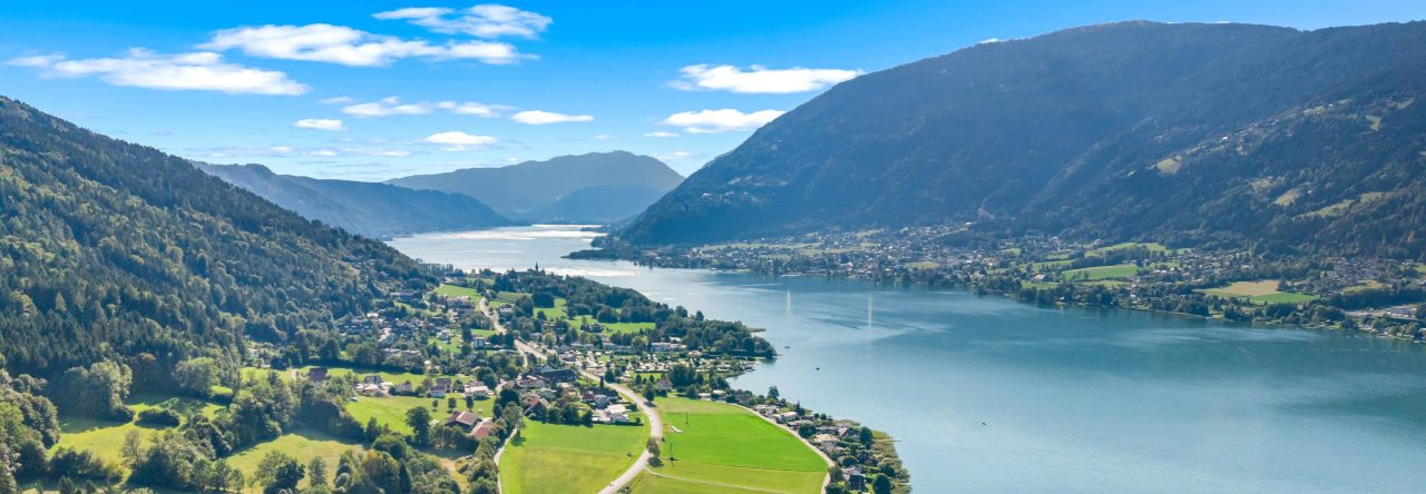
The Grossglockner Hochalpenstrasse is Austria’s legendary high alpine road—a 48-kilometre ribbon of asphalt that snakes through the heart of the Hohe Tauern National Park, connecting Bruck in Salzburg to Heiligenblut in Carinthia. This is not just a road, folks; it’s an experience. With 36 hairpin bends, the route climbs to dizzying heights—Edelweißspitze at 2,571 meters, and the iconic Kaiser-Franz-Josefs-Höhe, with jaw-dropping views of Austria’s tallest peak, the mighty Grossglockner (3,798 m).
Built between 1930 and 1935, the road was Austria’s answer to the Great Depression—an ambitious feat of engineering and optimism. Today, it’s one of the country’s top tourist attractions, drawing car enthusiasts, hikers, cyclists, and anyone with a pulse and a penchant for panoramic vistas.
The Adventure
Start your ascent at the Ferleiten toll booth, and let the serpentine road lead you ever higher. Each turn delivers new scenery: lush valleys, alpine meadows, and, if you’re lucky, a cameo by a marmot or two. Stop at the Edelweißspitze for a 360-degree view of over 30 peaks above 3,000 meters. If you’re feeling particularly intrepid, branch off to the Kaiser-Franz-Josefs-Höhe for a close-up of the Pasterze Glacier and maybe a selfie with the Grossglockner itself.
Along the way, you’ll find themed exhibitions, hiking trails for all levels, and a chance to spot the “High Five” of Alpine wildlife: ibex, golden eagle, marmot, Apollo butterfly, and alpine bumblebee. Don’t forget to check out the Haus Alpine Naturschau—where you can geek out over crystals, flora, and fauna.
General Info
General Info
Check the official website for up-to-date opening times, toll prices, and weather conditions.
Expect cooler temperatures and sudden weather changes—pack accordingly.
The road is popular with classic car rallies and cyclists, so don’t be surprised if you share your panoramic picnic with a vintage Porsche or a Lycra-clad peloton.
The Grossglockner Hochalpenstrasse is not just a road—it’s a journey through the heart of the Austrian Alps, with a side of history, nature, and a dash of adrenaline. Don’t forget to breathe. The altitude and the views will both take your breath away.
Pro Tips
Early mornings and late afternoons offer the best light (and fewer crowds).
Bring binoculars for wildlife spotting.
The weather can shift from balmy to brisk in minutes—layer up!
Don’t rush. The journey is as spectacular as the destination.
Whether you’re a petrolhead, a hiker, or just someone who likes their scenery with a side of adrenaline, the Grossglockner Hochalpenstrasse is a must-drive, must-see, must-experience slice of Austria.
Duration of the journey from Chalet Bjoerk: about 50 minutes (around 40km) via Villach and the Villach Alpine Road to the parking place P10 on the Rosstratten (toll needs to be paid – you can check prices here).
Recommended Equipment: good walking shoes or mountain boots if you plan to go hiking, water bottle, binoculars.
Bjoerk-Dobratsch
The Dobratsch
Since 80% of Villach’s the drinking water comes from the mountain, the protection of this water has top priority. For this reason, ski lifts were dismantled, enhancing a more gentle way of tourism. Today the hikers enjoy the summer. In the winter, the ski tourers love the local mountain of Villach, which is now a natural and water protection area of extraordinary importance.
The Villach Alpine Road
The well-developed road is 16.5 km long. It covers 1,200 altitude metres and offers spectacular views of Villach and its surrounding mountains and lakes. The mountain road is one of a total of five premium alpine roads in Austria. Start your driving fun in Villach-Möltschach, where the pay desk is to be found. First, quickly ascend via several turns passing the Alpen Arena with the ski-jumping facilities before the road opens far-reaching views of Villach, the Julian Alps and the Karawanks. Now follow the brim of the striking ridge on the wide road until it leads to the final destination, Rosstratte, with views of the Dobratsch summit beyond the timberline across alpine meadows.
View of Villach – skiing resort Gerlitze in the background
10 parking lots give you the chance to stop and enjoy the many highlights along the mountain road:
P0: Arena Lookout Platform Curve 2: View of the ski jump (also during the summer).
P2 View of the city and lakes, 862 m Stunning panoramic view of Villach.
P4 View of the Schütt, 1.020 m Impressive view of the “Schütt” landslide area, view of the Julian Alps and Karawanks.
P6 Alpine garden, 1.483 m Nearly 800 alpine plants from three climatic zones. Extra admission; open daily from the beginning of June to the end of August (time required: approx. 1 hour).
P6 “Red Wall” observation platform Stunning view 400 m into the deep rock face with a clear view of the Karawanks and the Julian Alps.
P1o Rosstratte, 1.732 m Panoramic view over most of Carinthia, the “Sun trails!” observation station, relaxing deck chairs, large adventure playground, Rosstrattenstüberl restaurant and “From the Ocean to the Mountain” geology trail. In the mornings, chamois can often be observed in the wild from the newly-built Chamois & Outlook Platform after a short 20-minute walk on the panorama trail to the summit.
Hiking on the Dobratsch
Numerous hiking trails run across the Dobratsch. Allow us to introduce you to the most beautiful routes on Carinthia’s striking alpenstock. Choose among easy family hikes, high-altitude hikes with great views, educational trails and round tours. Two very different hiking trails lead from the Rosstratte car park to the summit of the Dobratsch. While the meadow path is also suitable for untrained mountain walkers, the Jägersteig is recommended for sure-footed and experienced hikers. • Route 1 “easy” across the Elfernock to the German and the Wendish church Length 8.2 km | walking time 3 hours (there and back) | altitude metres 424 Hiking trail number 291 leads from the Rosstratte car park up to the summit of the Dobratsch at 2,167 m above sea level on an easily manageable route. Stop option: Dobratsch summit house. Tip: visit the two highest pilgrimage churches in the Eastern Alps! • Route 2 “sure-footed” across the Jägersteig to the Dobratsch summit: Length 4.3 km | walking time 3 hours | altitude metres 434 The Jägersteig also starts at the Rosstratte car park. First follow the tarmacked roadway past the Rosstrattenstüberl, then the gravel path. The narrow Jägersteig branches off at the first sharp right turn. It constantly runs up and down, with exposed and steep spots in places, and affords great views of the Gailtal and the Julian Alps. Reach the summit cross via the Dobratsch summit house.
Alpengarten Dobratsch
The 1.2-hectare site between the Villach Alpine Road and the brim of the Schütt is located only a few steps from car park P6. The site is open to visitors from early June to late August. Admission is affordable – not least because many volunteers nurture and cultivate the garden. The biodiversity of the alpine flora is particularly abundant, thanks to Carinthia’s location. The province is located at the intersection of several flora zones: arctic-alpine, central-European, Illyrian, sub-Mediterranean and sub-Pannonian plants. Numerous species also represent alpine limestone flora. Plants diligently arranged in 27 plant quarters can be easily identified due to meticulously placed name tags by volunteers! Marvel at early flowering plants in June, see the colourful main flowering from late June to mid-July and the tail forb blossoms with numerous late flowerings in August. Tip: take a look at the special features, such as the Wulfenia (native exclusively to Carinthia!), Austrian kidney-vetch and various types of lilies. If you’d take a piece of the Alpengarten back home, then feel free: seeds and seedlings are given away for a donation.
“Red Wall” Observation Platform
The Dobratsch owes its distinctive form to the two greatest landslides in the eastern Alps. Large parts of the unstable south side of the mountain crashed into the valley in 1348 due to an earthquake, releasing a total of 530 million cubic meters of rock over an area of 12 kilometres from the southern flank of the Dobratsch. As a result, the Gail River was dammed up, large parts of the valley area were flooded, and subsequently re-landed by Gail’s boulder. Today the so-called “Schütt” is a nature reserve with a special fauna and flora.
Looking into the beautiful Soca Valley in Slovenia
Short Facts:
Duration of the journey from Chalet Bjoerk: Round trip Chalet Bjoerk – Wurzenpass – Kranjska Gora – Vršič Pass – Soca Valley – Predil Pass – Tarvisio – Chalet Bjoerk can take up to a full day if you take a couple of stops. The driving distance is around 160km.
Recommended Equipment: good walking shoes, binoculars, passport
This round trip will take you to Slovenia and Austria, provide you with beautiful views, and take you back in time.
The first part of the trip from Lake Ossiach to Vršič Pass Starting from Chalet Bjoerk, you’ll take the winding road up the Wurzenpass to cross over to Slovenia. After you have passed the skiing village of Kranjska Gora, the winding road to the Vrsic mountain pass provides stunning views of the Julian Alps. The road through the pass rises from Kranjska Gora in a series of 50 hairpin bends, traverses the top of the Vršič Pass, and descends into the Soča Valley. The upper elevations of the road are rendered impassable by heavy snowfall during much of winter. The Isonzo Front of World War I greatly improved the road in late 1915, and it was originally named after Archduke Eugen of Austria-Hungary. The current name, Russian Road (Ruska cesta), refers to the approximately ten thousand Russian prisoners of war used as labourers in the 1915 construction. On the north side of the pass, just off the main road, at an elevation of around 1,200 m, a Russian Orthodox chapel built by the Russian POWs to commemorate their about 380 comrades who died the road construction. The Vršič Pass is the highest mountain crossing in Slovenia and the highest in the Eastern Julian Alps.
From Vršič Pass to Predil Pass 26 hair bin bends take you down to the beautiful Soca valley. Along the road, you will be able to see remnants of the First World War. The valley was the stage of major military operations, including the twelve battles of the Isonzo on the Italian front in World War I between May 1915 and November 1917. Due to its emerald-green water, the river is marketed as “The Emerald Beauty.” It is said to be one of the rare rivers in the world that retain such a colour throughout its length. The river’s course invites you repeatedly to park your car and take a few steps through the valley. For fishers of particular interest is the Soča Trout, which attracts fishers from all over the world. The marble trout is found in only a handful of drainages and rivers of the Adriatic basin. Following road 203 from Bovec to the north, you will arrive at the Kluže Fort. In the 15th century, it was a wooden fortification intended to prevent Turkish invasions in Carinthia. Later on, a stone fortification was built, defended by Austrian soldiers from Napoleon Bonaparte’s military in the 18th century. The fort obtained its modern view in the 19th century, while in the 20th century, it played an important role on the Isonzo Front. The Fort Hermann on the Mt. Rombon was built to support the Kluže Fort between 1897 and 1900. You can reach Fort Hermann by foot, from the Kluže Fort, on a wide marked route, carved into a rocky slope, through a 100 m long illuminated stone tunnel and then on the left path climbs the Rombon. The walk to the fort takes a little less than half an hour. Via the Predil Pass, you will cross over from Slovenia to Italy.
Lago del Predil Following the road down from the mountain pass, you will reach a beautiful lake at the foot of the mountain – Lago del Predil. Due to its picturesque setting beneath the Kanin massif, it is worth taking a break. For centuries, the southern border of the Imperial Duchy of Carinthia with the Venetian Domini di Terraferma ran along the nearby mountain crests of Predil Pass and Sella Nevea. After the Venetian territory’s loss to the Kingdom of Italy in 1866, the Austro-Hungarian Army from 1885 to 1887 had a fortress erected on the lakeside to protect the road down to Tarvisio. In World War I, the fort was badly damaged during the Battles of the Isonzo on the Italian Front. Some ruins are preserved and accessible to the public. On the way to Tarvisio, you will pass the village of Cave del Predil, which was once famous for the lead and zinc mines.
Tarvisio Located at the border with Austria and Slovenia, Tarvisio and its neighbouring municipalities of Arnoldstein and Kranjska Gora form the Romance, Germanic and Slavic Europe’s tripoint. As a former component of the Austrian Empire, until 1918, the town was overwhelmingly German- and Slovenian-speaking, as was the rest of the Canal Valley. Today the municipality speaks mostly Italian. For decades, Tarvisio benefited economically from people coming from Austria and Yugoslavia for shopping trips. However, trade at the notorious “Rag Market” diminished after the establishment of the Eurozone. Today, tourism and winter sports in the Karawanks, the Carnic Alps, and the Julian Alps have become important industries.
Using either the motorway (A23) or road SS13 (B83), you will get back to Villach and subsequently to Chalet Bjoerk.
Duration of the journey from Chalet Bjoerk: 10 minutes on foot / 2 minutes by car Recommended Equipment: comfortable walking shoes, binoculars, camera
The Bleistätter Moor is almost only a stone’s throw away from our house. It is located at the east end of the Ossiacher See and invites you to walk, jog, watch and linger.
The area has advanced from an ecological problem child to a refuge for unique flora and fauna. You can now discover cranes, kingfisher, bat, dragonfly, beaver and Co. along the hiking trail.
With an area of around 600 hectares, the Bleistätter Moor was once considered to be one of the largest bog areas in Carinthia. At the beginning of the 1930s, the construction of drainage systems began. The land gained has been used intensively for agriculture by the local farmers for decades. Therefore, fertilizers and pesticides washed out got into the Ossiacher See without a filter effect, which worsened the water quality, especially in the eastern bay. Many nutrients also got into the lake through the Tiebel river. With the rehabilitation and flooding of the westernmost part of the moor, the lake’s water-ecological quality has greatly improved.
An important water and nature conservation project was implemented with the flooding and renaturation of the Bleistätter Moor
The slow trail is around seven kilometres long (max. 2 hours walking time), leading to several routes through the species-rich nature and European nature reserve of the Tiebel estuary. Since then, around 80-hectare area was flooded in spring 2017, an attractive habitat has developed here that is home to rare animal and plant species. Over 200 different species of birds have already been observed. These include real rarities such as the shy kingfisher, cranes, white and black storks, ospreys and booted eagles and many more. Furthermore, you can see the only two-millimetre small Desmoulin’s whorl snail, at least 14 bat species – including the very rare Daubenton’s bat – as well as numerous amphibians and over 700 species of butterflies, such as the EU-wide protected Large copper. Many fish species also enjoy the flooding basin, such as the Ossiacher See’s carp, which now finds optimal spawning areas thanks to the newly created shallow water areas.